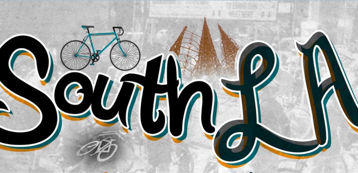
About one hundred cyclists are expected to attend a group ride on June 17 that will celebrate and test a South Los Angeles bicycling map developed by communication professor François Bar.
They will hand out free copies of the first map from RideSouthLA.com, a coalition of groups that are promoting bicycling in South LA and revealing community assets, including the Watts Towers, along a recommended bike route. The group ride starts at 10 a.m. at Augustus Hawkins Nature Park (5790 Compton Ave.), continues to the icohttp://www.thewrap.com/nic Watts Towers, runs along the Metro Blue Line, and includes a visit of the Watts Labor Community Action Committee before looping back to the Nature Park. The map is the first of its kind, designed with the help of community organizers and residents to encourage biking in South LA while highlighting social justice. Data and pictures for the map were gathered live in January, using a custom tool from the Annenberg Innovation Lab called ParTour. This return ride challenges cyclists to find what the print map is missing, and to supplement it with their own live stream of pictures highlighting neighborhood assets they feel should be added. High-tech features included iPads mounted to roving bikes to monitor incoming pictures. Low-tech is equally important.
"We support basic cell phones — anything that can take pictures,” Bar said. “The mobile ParTour platform builds on the dozens of geo-coded photos cyclists sent during the ride, and their comments about what makes the neighborhood special.” "Our goal with each map project is to bring awareness to a different aspect of South LA culture that is easy to bike to and enjoy for both residents and visitors," said Tafarai Bayne, Community Affairs Manager with T.R.U.S.T. South LA. "After our launch for the Map to Watts, everyone demanded we take them on a group ride. We are very excited to deliver! We are hoping to raise awareness about our project so we can get more maps funded and produced as soon as possible. The maps and rides are intended to give people ideas on how the land in South LA is being used and to help spark conversations on the ways Land Use can be improved in the community."
Sunday’s route is co-led by the East Side Riders (ESR), one of the bicycle clubs and education groups that calls Watts and Firestone home. “We see the map and the rides as a way to advocate for safe biking, but also for community service and engagement” said John Jones, who co-directs ESR. Other South LA bicycle clubs will be represented as well, including the Real Rydaz, the Compton Schwinn Masters, and the newly formed Los Ryderz. Joining with residents will be cyclists from all over the city, from Eagle Rock to Long Beach and Santa Monica. According to John, “what starts as a bike ride is also a chance to connect across neighborhoods.”
The partners behind this effort point to a broad social agenda -- from city planning to bicycle and social change advocacy. Central partners include T.R.U.S.T. South LA, Bikerowave, the East Side Riders Bike Club and C.I.C.L.E. “The re-imagination of urban space only happens if the ride is integrated into the community’s storytelling network,” said project researcher George Villanueva of USC Annenberg’s Metamorphosis project. He said that the reversal of the negative depiction and disinvestment in South LA must go “beyond mainstream media organizations and government institutions, and must include residents and community-based organizations.” Situating community engagement through live picture-taking with mobile phones has civic importance. “A different LA depends on group experiences that engage participants in accessible and meaningful activities,” said doctoral student Benjamin Stokes. “Riders as a group of community mappers engage with the city by opening their eyes and ears to what’s unique to that place. Real-time community mapping is about experiencing LA differently.” The map encourages riders to “get involved,” and provides instructions for requesting bike racks from the city, mobilizing your network, and joining campaigns for change. The companion website, RideSouthLA.com, allows cyclists and residents to submit additional pictures, and gives more detail on how to take action.
The website and print map are designed to interrelate, with each form supporting the other.
“Online distribution may be cheap, but paper distribution is often necessary to engage at the street level,” notes team member and USC staff Otto Khera who also lives in South LA with his wife and two children. The mapping approach and technology comes from the ParTour project at USC Annenberg, which is a joint effort of AIL and the Metamorphosis Project, which has studied and engaged changing urban communities in Los Angeles for more than 10 years under USC Annenberg Professor Sandra Ball-Rokeach. The underlying technology builds on tools previously deployed through Mobile Voices, which allow anyone with a camera phone to send photos via text message to a computer that places the photos on a map. To build the map, organizers in January simply asked cyclists to take photos of anything they found interesting, which ranged from mosaics in Metro stations and dolphin statues in front yards, to neighborhood stores and scenes of the parade of bikes. Moving forward, the RideSouthLA team hopes to create additional maps, distribute the maps widely, coordinate and advertise future rides in South LA, and continue to engage the South LA community to deepen its storytelling networks. The maps will be available in print and online, following the Mobile Voices model. In that project, after stories were published online, the team printed them in a newspaper that could be distributed in labor centers and on street corners for those who don’t have Internet access.
For the latest details, see the event’s Facebook page.